Why use LEGO®? It's fun! It's tactile, it stimulates creativity, it allows visualisation of designs, it's flexible, it appeals to all (specifically boys, who are statistically underachieving) and can be re-used again and again and again and again....
Just mentioning a link between LEGO® and Geography lessons is often enough to get teachers thinking creatively, but here are some examples of just some of the ways you can use these little bricks in your lessons.
1. Make a flag
Useful aid to get students using an atlas or the internet in a research-based capacity. Perhaps get students to make the flag from LEGO®, write down some key facts about the country (or mini-paragraph linking your topic to the relevant country) and photograph their writing next to their flag.
2. Grouping / categorising
Get some chunky bricks, some stickers (address labels cut to size may be useful here) and go for it! Maybe you will do locational Geography such as matching countries to their capitals. You could use it for fun case study revision with KS4 - 5 by getting them to match case study title with other essential information such as year, cause, effect, location....
You can get students to photograph their correct answers to help with their revision.
3. Create a landscape
LEGO® bricks can be moved. Landscapes move. This may take a bit more time to set up but could be a valuable way of getting students to demonstrate their understanding.
An example could be showing the formation of a gorge caused by waterfall erosion. You can get students to create it, photograph each stage, print it as a storyboard and explain each step.
Otherwise there is soil, rock, water tables, volcanoes, earthquake simulation...
4. Designing
Perhaps an eco-friendly house, flood defences along a river or coast, an ecolodge, a small yet efficient house within a favela....
5. And more!
I'm currently planning how to paint a world map on to a large LEGO® board so I can use it flexibly within lessons. Imagine giving everyone a brick and asking them to place it on the country that is the furthest place they've ever travelled. The taller the country's tower, the more students have been to that place. Imagine the conversations that could stimulate. Imagine the other ideas that are possible here.
I'd love to hear from you if you have used LEGO® in your lessons. What did you do? How did the students react? What were the pros and cons? Would you do it again?
Showing posts with label distribution. Show all posts
Showing posts with label distribution. Show all posts
Wednesday, August 3, 2016

Friday, May 27, 2016
Exam Skill: Describing Distribution
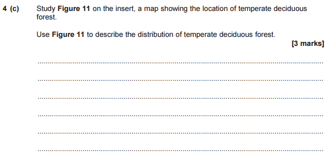
Most Geography exams will have at least one question that goes something like this, "Describe the distribution of...." It could be a biome such as rainforest or tundra, it could be world population, it could be earthquakes or volcanoes. These questions will be accompanied by a map. Something like this....
And a question like this...
But what is this actually asking you to do? Something that trips up a lot of students on questions like this is that they don't actually know what distribution means. It was something highlighted in the Examiners Report for this particular exam...
So distribution is about how something (in this case, temperate deciduous forest) is spread out. It's about looking for patterns in location rather than listing or stating different locations they can be found. Let's look at the mark scheme for this particular question...
So instead of describing the location of the forests you need to describe how these forests are spread out over the world. This can be confusing for many students as you obviously need to describe location to some extent, but it goes further than that. Here's the examiner comments for this particular question...
So don't just say "they can be found in Europe, USA, Southeast Asia, New Zealand and East Australia".
Do describe patterns in their location. "The vast majority of temperate deciduous forests can be found in the Northern Hemisphere, North of the Tropic of Cancer. The biggest expanse being in Western Europe reaching into Russia and West Asia. A smaller cluster can be found South of the Tropic of Capricorn on the East coast of Australia and all over New Zealand. These forests do not occur within the tropics...."
It's not an easy skill for a lot of a students so it's worth practising key words and skills that help describe distribution.
 |
| From AQA Unit 1 (H) paper, May 2015 |
 |
| From AQA Unit 1 (H) paper, May 2015 |
But what is this actually asking you to do? Something that trips up a lot of students on questions like this is that they don't actually know what distribution means. It was something highlighted in the Examiners Report for this particular exam...
 |
| For the full report on this exam go to http://filestore.aqa.org.uk/subjects/AQA-90301H-WRE-JUN15.PDF |
So distribution is about how something (in this case, temperate deciduous forest) is spread out. It's about looking for patterns in location rather than listing or stating different locations they can be found. Let's look at the mark scheme for this particular question...
 |
| From AQA Unit 1 (H) paper, May 2015 |
 |
| For the full report on this exam go to http://filestore.aqa.org.uk/subjects/AQA-90301H-WRE-JUN15.PDF |
So don't just say "they can be found in Europe, USA, Southeast Asia, New Zealand and East Australia".
Do describe patterns in their location. "The vast majority of temperate deciduous forests can be found in the Northern Hemisphere, North of the Tropic of Cancer. The biggest expanse being in Western Europe reaching into Russia and West Asia. A smaller cluster can be found South of the Tropic of Capricorn on the East coast of Australia and all over New Zealand. These forests do not occur within the tropics...."
It's not an easy skill for a lot of a students so it's worth practising key words and skills that help describe distribution.
- Confidence using North, South, East and West
- Naming important lines of latitude (Equator and Tropics, but point out these are often marked on their maps!)
- Continents (though again, they're often labelled on the maps)
- Main oceans
- Even, uneven, sparse, dense, clustered
I hope this is helpful for teachers, students and parents. Please leave a comment if this was useful, or if there's anything else you'd like to know!
Good luck!
Subscribe to:
Posts (Atom)